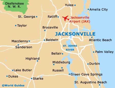
Jacksonville International Airport (JAX)
Orientation and Maps
(Jacksonville, Florida (FL), USA)
Whilst situated on the northern side of Florida, Jacksonville has a true southern feel and is a spreading city, being the second biggest in overall size in the whole of America. Close to the actual mouth of St. John's River, the city of Jacksonville is often overlooked and contains many sights worth seeing, both natural and manmade.
Many people visiting the city arrive at Jacksonville International Airport (JAX), to the north, where hire cars, taxi cabs and local buses are all waiting. Jacksonville's Greyhound bus station stands on Pearl Street and provides buses to a number of cities around Florida, such as Miami (7 hours), Tallahassee (3 hours) and the theme park capital of the world, Orlando (3 hours). Those arriving by train will find the city's Amtrak train station off Clifford Lane, while local buses are run by Jacksonville Transit.
Jacksonville International Airport (JAX) Maps: Important City Districts
Amongst the most popular places of interest in the city, the Southbank Riverwalk is especially appealing and is a scenic boardwalk, stretching for around 1.5 miles / 2 km alongside the meandering St. John's River. The river walk connects many hotels, restaurants and galleries.
The tourist information center in Jacksonville is sited along East Adams Street and operates three additional booths, which can be found at Jacksonville Airport, along the Beach Boulevard and on Independent Drive. Many people choose to take their vacation in this part of Florida because of the seemingly endless stretches of sand. The city's beaches have become legendary in the area and are warm for most of the year. Surfing is especially popular off Atlantic Beach, while Jacksonville Beach is known for its swimming and nearby nightclubs.
USA Map

Florida Map

Jacksonville Map